
The Story of the Snowy Range: 2 collisions & 2 billion years!
In the early 1980s, author John McPhee was gathering information for a book—"Rising from the Plains"—about Wyoming geology. He crossed the state on Interstate 80 from east to west, in the company of one of the grand old men of Wyoming geology, John David Love. McPhee took notes while Love drove and expounded on the landscape.
Near Laramie they looked west at distant mountains. McPhee was struck by the illusion: "... the Medicine Bow Mountains and the Snowy Range stood high, sharp, and clear, each so unlike the other that they gave the impression of actually being two ranges ... the flat-crested Medicine Bows, dark with balsam [subalpine fir], spruce, and pine; and, in the far high background, the white and treeless Snowy Range."
But the latter sits atop the former. Geologically speaking, they are a single range.
Ancient sediments
In 1868, just a few months after Laramie was established, Arnold Hague became the first geologist to explore the Medicine Bows. In his 1877 report, Hague described a flat-crested mountain range with "elevated plateau country, nearly 10,000 feet above sea-level ... dotted over with numerous alpine lakes." From this high surface rose a sharp-edged ridge that "culminates in Medicine Peak, a grand, broad central mass." [That surface is now Libby Flats, the ridge the Snowy Range, and the high point Medicine Bow Peak.]
"... the amphitheatres, with mural faces 1,500 feet deep, cut out of pure white quartzite, are very striking," wrote Hague. The peak itself "is a mass of pure white quartzite, rising nearly 2,000 feet above the surrounding country ..." He assigned the quartzite to what was then called the "Archean series"—the oldest rocks on Earth, specific age unknown. At that time, it was the best a geologist could do.
Hague found thin layers of pebbles and other signs of bedding in the quartzite, convincing him it had started as deposited sediments. He also concluded that the beds, originally horizontal, had been steeply tilted. But if he had further thoughts about how the quartzite and ridge formed, he didn't share them.
Geology graduate student Charles Van Hise of the University of Wisconsin crossed the Medicine Bow Mountains on horseback in 1889, in just three days. At the crest, he examined the rocks, taking notes for his PhD dissertation about North America's Precambrian rocks (equivalent to the "Archean series" used by Hague). Like Hague, he described the quartzite as ancient and sedimentary.
Neglected no longer
In 1917, a third geologist came to southeast Wyoming to study the Medicine Bow Mountains. "Dr. Eliot Blackwelder, head of the department of geology at the University of Illinois arrived in this city this morning ..." reported the Laramie Boomerang on July 24. He would "start on a geological expedition in the Medicine Bow mountains in a few days." Like Van Hise, Blackwelder was interested specifically in the ancient rocks at the crest.
Blackwelder found the Medicine Bows a wonderful place to work, as he explained in his report. "In spite of its ready accessibility, this interesting range has been strangely neglected by geologists until the last decade. ... no detailed work seems to have been attempted." He would fill that gap, spending six weeks in the range in 1917, and a month in 1925.
Blackwelder published "Precambrian geology of the Medicine Bow Mountains" in 1926. He named the "great, massive quartzite" of the Snowy Range the Medicine Peak quartzite, and described it as "extraordinarily thick"—on the order of 5600 ft. He too concluded it consisted of metamorphosed sediments, and dated from Precambrian time (and still without a specific age). Unlike his predecessors, however, Blackwelder offered a probable scenario for its origins.
Reading the rocks
Like all quartzites, the Medicine Peak quartzite started as quartz sand, became sandstone, and then was metamorphosed under intense pressure to its final form—very hard rock that sparkles in the sun. Yet even with this major transformation, the quartzite still provides clues about its ancient birthplace. Blackwelder often spotted ripple-marks and cross-bedding (layers at angles), evidence that the sand had accumulated in shallow active water. He suggested it was deposited just offshore, where it would be shaped by waves, or streams flowing into the sea.
And yet the quartzite was so thick—at least 5600 ft even after compaction and metamorphism! How could so much sand accumulate in shallow water? Blackwelder turned to a modern-day analogy. "The great thickness of pure quartzite represents sifted sand that might have been deposited and worked over on a marine shelf, like that around Cape Hatteras, on the Atlantic coast of the United States."
But if so, how did sand on a marine shelf become quartzite 11,000 ft above sea level, far from any ocean? In Blackwelder's day, there was no good answer for this kind of question. It would be almost 40 years before enlightenment arrived.
Earth's dancing plates
By the early 1960s, geologists had accumulated enough evidence to put forward the theory of plate tectonics, now widely accepted. The Earth's rigid outer shell, the lithosphere (crust and upper mantle), consists of giant "tectonic plates" that grow, break, stretch, compress, dive under, thrust over, and collide in a slow but powerful dance. In the process, landscapes are changed on a grand scale.
It was the movement of tectonic plates that created the Snowy Range. Here's the basic plot: Along the Wyoming coast, a massive amount of sand accumulated offshore. A plate collision pushed up mountains, metamorphosing and tilting the sand(stone). These mountains were worn down, their remnants buried. Then another tectonic confrontation pushed up the Medicine Bow Mountains. Erosion exposed the ancient quartzite and shaped the Snowy Range.
The former world
The Medicine Peak quartzite started as sand 2.1 billion years ago. Back then, Wyoming was part of Superia, a smallish supercontinent. But Superia was coming apart, leaving Wyoming on the coast of a growing ocean. Sand and other sediments would accumulate just offshore for some 200+ million years.
But then something changed, something huge! Exactly "what" may be lost to deep history, or maybe not yet discovered. In any case, the widening ocean disappeared.
Collision and a continental suture
In their studies of the quartzite, Hague, Van Hise, and Blackwelder all could see that the beds of sand, which were horizontal when deposited, were now far from it. "In general the sedimentary beds are nearly vertical or steeply inclined to the southeast," wrote Blackwelder. They had been tilted almost 90 degrees!
The cause was continental collision. About 1.78 billion years ago, a smallish tectonic plate called the Green Mountain Terrane bumped up against the Wyoming coast. This "collision" went on for 40 million years, producing a continental suture called the Cheyenne Belt—a zone of highly deformed rocks.
As is typical for such a collision, a mountain range was pushed up, tilting the sand-turned-to-quartzite on its side. But that mountain range is now mostly gone. As permanent as they may seem to us, mountains have lifetimes. As soon as they rise, erosion goes to work wearing them down, sometimes burying them in their own debris.
The remnants of the ancient range would lie buried for hundreds of millions of years, while sediments accumulated to great thickness. The quartzite would be covered by tens of thousands of feet of limestone, sandstone, and shale by the time the next big change arrived.
West Coast happenings felt in Wyoming
The Medicine Bow Mountains were uplifted during a great mountain building event called the Laramide Orogeny. It started 80 million years ago, lasted almost 40 million years, and created mountain ranges from Mexico to Canada—the Rockies. In contrast with the previous collision, this time the plate jostling was remote. Almost a thousand miles to the west, the oceanic Farallon plate was diving under the North American plate, compressing the continent and pushing up mountains far inland.
Of course, as soon as the Medicine Bow Mountains rose, erosion set in. Eventually enough of the sedimentary rock cover was removed to expose the ancient Precambrian core. Being super hard and durable, the Medicine Peak quartzite eroded much more slowly, and was left as a high-standing ridge. As Eliot Blackwelder would write 40 or 50 million years later, "The Snowy Range owes its prominence and position to a great, massive quartzite formation."
Field trip (you too can read the rocks!)
Zero your odometer at the junction of Highways 130 and 230 in West Laramie. Drive west on Hwy 130, the Snowy Range Road.
1. At 36 miles, turn right and park along the Brooklyn Lake Road near Nash Fork Campground. To view a bit of the 1.78 billion year old continental suture, walk into the campground, stay left on the loop, and just past the fee station and site 27, walk left (west) 20 or 30 yards to dark rock above the highway. Look around your feet for fine laminations, with waves and tight chevrons created by continental collision. Then check the two huge white quartzite boulders (dropped here by glaciers) for cross-bedding from deposition offshore, and gray bands with white pebbles flattened during collision.
2. At 40 miles, visit Libby Flats observation point (with restrooms and a "castle"). Enjoy Arnold Hague's "elevated plateau country ... dotted over with numerous alpine lakes."
3. A quarter mile farther west on Hwy 130, turn left to Medicine Bow Peak Over Look, with excellent interpretive signs. On the Snowy Range diagram, find The Diamond with Mirror Lake below—location of Blackwelder's photo included here, and the next stop.
4. Continue west 1.3 mile to Mirror Lake Picnic Area. Near the entrance, compare your view with Blackwelder's photo. In looking at the spectacular face, remember ... it is beds of sand turned vertical! From the highpoint of the loop, examine the large dark dike—magma injected into the quartzite (see Blackwelder photo).
5. Continue west a short distance to the first of two Lake Marie parking lots. At the east end, explore the field of white quartzite boulders. Bedding and cross-bedding are common. Search to find gray bands with flattened white pebbles, evidence of plate tectonics in action!
By Hollis Marriott
Caption: Medicine Peak quartzite above Mirror Lake. Added arrow points to a huge dike—magma injected into the quartzite (the prominent dark vertical band left of the peak is a shaded shallow rock wall).
Source: E. Blackwelder, 1926. Bull. Geol. Soc. Am.
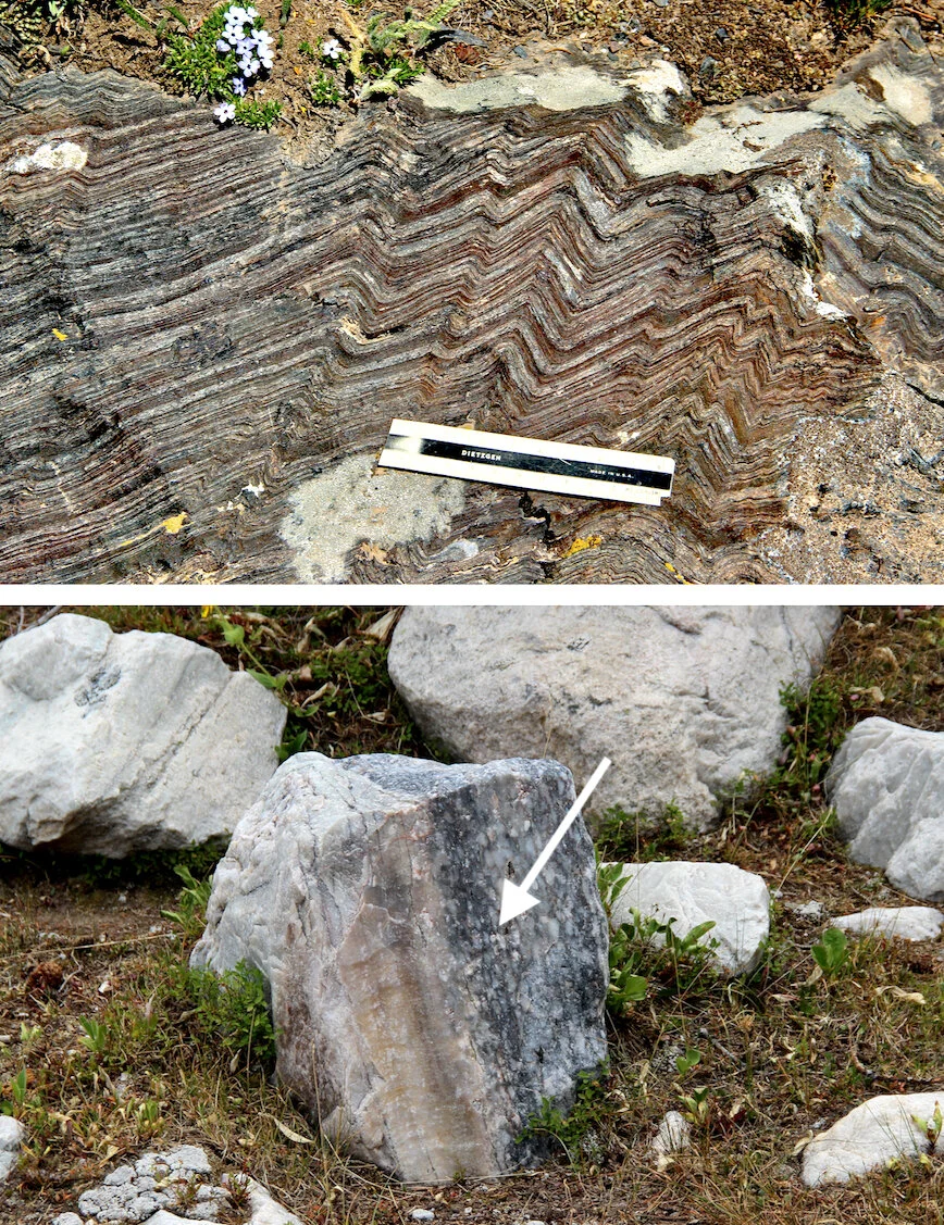
Caption: Products of plate collision 1.78 million years ago. Top: deformed rock of the continental suture, Nash Fork Campground (ruler is 6" long). Bottom: flattened pebbles in a quartzite boulder, east Lake Marie parking lot.
Source: H. Marriott photos.