1920 airfield along east Grand Ave.; Now the site of UW dormitories
A government map of Laramie created around 1920 but published in 1924, shows the first airplane landing field established here. It was set up for the use of airmail pilots. The U.S. Postal Service had just begun coast-to-coast airmail using a route going directly over Laramie. The Postal Service bought the airplanes, hired the pilots and arranged for all the infrastructure necessary to support the service.
The section between Cheyenne and Salt Lake City could be flown without any stops if the weather and airplane condition were favorable. But if a pilot ran into difficulty, emergency landing fields were needed.
Flights were made only in the daylight hours because the pilots had no reliable navigational devices—their magnetic compasses were affected by all the metal in the planes. Therefore pilots depended upon what they could see on the ground, using the tracks of the Union Pacific Railroad (UPRR) as their guide to Salt Lake City. On this leg of the trip, the pilots took off from and returned to Cheyenne, where the airplanes and pilots were based.
Daily flights were scheduled, sometimes round-trip the same day. Weather could wreak havoc with the ability to fly, though pilots commented that the air was much clearer most of the time on this segment than it was east of Cheyenne. One pilot, Jack Knight, said visibility was poor east of Ogalalla, so he’d rather fly the Cheyenne to Salt Lake route. “There seems to be a permanent greasy fog in that country almost all the time,” he said, commenting on the visibility along the Cheyenne to Omaha section of the route.
Emergency fields
Eventually the Postal Service established 40 emergency landing fields for pilots between Cheyenne and Salt Lake City. Municipal Field in Laramie was one.
In the Laramie area, a local volunteer committee got busy when the first airmail flights from Cheyenne began around September 10, 1920. The emergency landing site was ready for use by the airmail pilots on November 18, 1920. Unfortunately, about two weeks earlier the first fatal crash of an airmail plane had happened in Albany County on November 6, in a snowstorm near Tie Siding. Pilot John P. Woodward crashed his plane into Red Buttes as he was making the return trip from Salt Lake.
Municipal Field
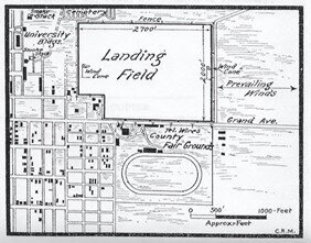
Looking at the 1920 site map now, it’s hard to believe that this land now occupied by UW dormitories and stadium was once an airfield on the edge of town. There is a tiny remnant of the former 80 acre field—Fraternity Mall on the northeast part of the landing field, though there were no fraternities or sororities there in 1920.
It was the newly-formed Laramie Council of Industry that answered the call from the Postal Service to develop an emergency landing site and, after inspecting several possibilities, decided that the vacant plot south of the cemetery and east of the UW campus would be best. A subcommittee of the Council, composed of banker A.C. Jones, grocery store owner T.H. Simpson, and druggist A.H. Cordiner, chose the site and secured permission from several landowners.
One that gave permission was the Episcopal Children’s Home (later to become Cathedral Home) which was located in the old St. Joseph’s Hospital building, shown on the detail map as in the middle of the block between 15th and 16th Streets.
The Council arranged to have fences on the site removed, and it secured the loan of city and county equipment to help grade the field. The site was already mostly level, but gopher and prairie dog holes had to be filled on this recently cultivated land. The only amenity that was added were the wind “cones” that the Council provided. The Council also submitted the 1920 general and detail maps that could help guide the pilots. The 1903 racetrack of the County Fairgrounds between Grand Ave. and what is now Washington Park also became a navigational aid as shown.
The Postal Service had also asked that all towns along the Cheyenne to Salt Lake route paint the town name in white six-foot high letters on the tallest building. So the Council arranged for that to be done on the five-story Holliday Store at 2nd and Garfield St. (it was lost in a 1948 fire). Eventually, when Half-Acre Gymnasium on the UW campus was built in1925, it sported on the roof an icon of an airplane, with an arrow pointing to the municipal airfield, just to the east of that building.
Pilot information
The maps accompanying this story were mandated by the Postal Service, with all amenities noted. They were given to the airmail pilots, though the Air Service of the U.S. Army published the one of Laramie’s Municipal Field in 1924. There wasn’t much information given about amenities at Municipal Field because other than the windsocks, there really weren’t any.
However, the maps do note the hazards present—tall smokestacks along the UPRR tracks and at the University. Also identified are the telephone wires along Grand Ave. which was the Lincoln Highway at the time. “Meteorological Data” consisted only of the note indicating that the prevailing wind was “east and west.” If the plane needed repairs after landing at Municipal Field, it was suggested that the Franklin Motor Car Co. in downtown Laramie could be contacted, indicating that at the time airplanes were not much more complicated than automobiles.
For communications, the pilot was told to go to a telephone “in the southwest corner of field,” though there was no building there—there was no hangar or shelter of any kind at Municipal Field. However, the Episcopal Children’s Home was just two blocks west of the field edge and that building may have contained a telephone, which might have been useful for a pilot in an emergency.
Airplanes a curiosity
Although the Council of Industry had high hopes that the Municipal Field would be used by private pilots as well as the Postal Service, there is almost no record in the newspapers of that happening. Commercial air travel was non-existent at the time. Early aviators were mainly WWI veteran pilots who took paying passengers for sight-seeing rides and for aerobic demonstrations at county fairs and the like. Some pilots, like Laramie’s Fred Wahl, eveloped landing strips on private ranches and had no need for the Municipal Field.
One airplane did land at Municipal Field on July 4, 1921. The pilot had been contracted to pick up a reel of film from the westbound UPRR, showing the Dempsy-Carpentier championship boxing match that took place in New Jersey on July 2. It had been rushed by rail cross-country to Laramie, and then was flown to San Francisco where a crowd was awaiting to see the knockout punch that Dempsy dealt to the French challenger. It had been heavily promoted, and was the first world title fight to be carried on radio, but apparently there was still an audience eager to see the film.
In the early 1920s airplanes were rarely seen. Only 17 years earlier the Wright brothers’ first flight at Kitty Hawk, North Carolina had occurred, and there had been a debilitating world war and the Spanish Flu pandemic in the meantime. It was newsworthy whenever an airplane was heard to go overhead, as people in Laramie had not yet gotten used to the novelty. Typical is a note in the Laramie Republican of Dec. 4, 1920, noting: “An air mail plane, en route from Cheyenne to Salt Lake, passed over this city this morning at 7:40 a.m. flying high.” The first round trip in one day was made by pilot James F. Moore, who passed over Laramie twice on Dec. 17, 1920. He left Cheyenne at 6:42 a.m. and returned to Cheyenne by 4:44 p.m. His flying time was eight hours and 32 minutes for the 800 mile round trip; each way carrying 400 pounds of airmail.
Reading the maps
In studying the accompanying maps showing the Municipal Field, the reader might note that the maps drawn in November of 1920 show features that had changed a little before being published by the U.S. Government Printing Office in 1924. For one thing, the Cooper House, now the home of the American Studies branch of the UW History Department, was built in 1922, yet it is not shown. There is a small building facing Ivinson Ave. (then called Thornburgh St.) at the back of the otherwise empty block where the Cooper house would sit, between 14th and 15th Streets.
What was to become 15th St. is shown petering out just north of what is now Ivinson Ave., and the route to the cemetery appears to be an unpaved road leading from the UW campus diagonally to the south end of the cemetery.
The buildings of the Albany County Fairgrounds are clearly shown on the map though one building known the be there, the National Guard Armory, is not shown. In the 1920s the Guard was in a long, low stable, dating back to the days when the military used horses. It was located where the Regal Theater building is now on 20th St. That street didn’t exist at the time of this map. The fairgrounds were moved around 1947 to the current location south of Laramie on Highway 287, according to Laramie Plains Museum historian, Jerry Hansen.
It is evident from looking at the smaller scale map that Grand Ave. had become a major east/west route through town, and across the Laramie River. There was much newspaper comment in the early 1920s about the dangerous Grand Ave. grade level crossing over the UPRR tracks. It wasn’t until 1930 that the first auto viaduct over the tracks was opened. It was at University St.—the Grand Ave. crossing was finally closed then. However, until the viaduct opened, the city did install a watchman at the Grand Ave. crossing in an attempt to cut down the number of accidents.
Council of Industry
The Laramie Council of Industry had evolved from a similar organization that had formed before 1900 to encourage development in Laramie and Albany County. That group had encouraged and supported some infrastructure improvements like an electric plant and telephone service. However, some of their industrial projects like a Laramie glass factory and a flour mill were short-lived.
Some work of the 1920s Council of Industry was destined to be short-lived also, including the Municipal Field. We don’t know what caused this first airmail emergency landing field to be replaced by another south of town. The new 1927 site east of Soldier Spring road was featured in a Boomerang history story published October 25, 2020 titled: “Airmail puts Laramie on the map in the 1920s.” Still, the work of the Council of Industry was important to demonstrate that Laramie welcomed economic development.
By Judy Knight
Source: U.S. Government Printing Office
Caption: View of Laramie and the Municipal Landing Field on Grand Ave., from a map submitted in 1920. Note the Railroad spur lines going to two different industrial sites on the southeast; another going across the river to Centennial and Coalmont, CO. Also note Spring Creek meandering through Undine Park prior to being channelized to the south several blocks
Source: U.S. Government Printing Office
Caption: Detail of Bulletin No. 166, showing the area around the Municipal Landing Field with details to aid pilots, including the County Fair Grounds with its racetrack that could be easily seen from the air.